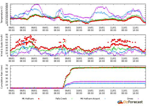
(Updated) Rainfall at Mt Hotham is a pretty good analogue for river flow on the Wonnangatta-Mitchell. The river flows at approx 4km/hr. Use that fact to time the canoeability of sections.

For example, on Monday (9 Jan) it rained steadily all afternoon and there was 63 mm of rainfall at Mt Hotham by the time it stopped around 9pm. The whole valley got a good soaking. You can check this is happening by comparing eg rainfall at Dargo. You can see that it is raining by checking the radar. I use http://ozforecast.com.au/cgi-bin/weather.cgi?station=Mt+Hotham.VIC&radar
By 2.52am on the 10th the river had started rising at Waterford (from a low of 1.72metres). By 14.22pm it had reached 1.80 metres which is the recommended canoeable height for the section downstream of Waterford (& indeed all the way from the Humffray). I would be fairly confident of setting out from the Kingwell Bridge at 1.75 metres height as measured at Waterford with a flow like this coming down behind me.
It rose to 1.84 metres at 21:17pm on the 10th, stayed there until 8: 52am on the 11th and then began falling. By 19:17 on the 11th the river had returned to 1.80 at Waterford. So, the river remained canoeable for 29 hours. (Update: I now know the river is canoeable at 1.75, and probably at 1.70!)
NB: On AdventurePro’s website they claim the river is canoeable downstream from Angusvale at .6 metre on the Glenaladale gauge: https://www.adventurepro.com.au/paddleaustralia/pa.cgi?action=details&id=mitchell This would probably work out at less than 1.5 metres on the Waterford gauge! They claim the same height for the section Waterford to Angusvale: https://www.adventurepro.com.au/paddleaustralia/pa.cgi?action=details&id=Mitchell1
Since the bushfires summer flows have been deplorably low and will likely remain that way for many years. You have to catch the wave! If you started out from Waterford before 19:17 on the 11th you would ride that wave all the way to Glenaladale (except you would have to sleep!)
If you anticipated the wave you would be able to start at Waterford on the morning of the 10th and still have two days of beautiful canoeing down to Angusvale. There is going to be 12-20mm of rain again at Hotham on Friday 13th. The rain is going to come in about midday and continue until after midnight.
Saturday and Sunday the river should be canoeable anywhere from Eaglevale down and the weather should be fine and about 26C. This should be a good weekend on the Wonnangatta. Enjoy!
NB: A follow up on this post appears below the data:
Mt Hotham Rainfall Totals:
| Tue 00:00 EDT | N | 31 | 41 | 12.3 | – | 9.5 | – | – | 62.6 | 0.0 | – |
| Mon 23:50 EDT | N | 31 | 35 | 12.2 | – | 9.3 | – | – | 62.6 | – | – |
| Mon 23:40 EDT | N | 31 | 35 | 12.2 | – | 9.3 | – | – | 62.6 | – | – |
| Mon 23:30 EDT | N | 35 | 43 | 12.4 | – | 9.4 | – | – | 62.6 | 0.0 | – |
| Mon 23:20 EDT | N | 33 | 37 | 12.4 | – | 9.5 | – | – | 62.6 | – | – |
| Mon 23:10 EDT | N | 39 | 44 | 12.4 | – | 9.2 | – | – | 62.4 | – | – |
| Mon 23:00 EDT | N | 35 | 44 | 12.4 | – | 9.4 | – | – | 62.4 | 0.0 | – |
| Mon 22:50 EDT | N | 33 | 37 | 12.4 | – | 9.5 | – | – | 62.4 | – | – |
| Mon 22:40 EDT | N | 39 | 44 | 12.4 | – | 9.2 | – | – | 62.4 | – | – |
| Mon 22:30 EDT | N | 35 | 46 | 12.3 | – | 9.3 | – | – | 62.2 | 0.0 | – |
| Mon 22:20 EDT | N | 28 | 31 | 12.2 | – | 9.6 | – | – | 62.2 | – | – |
| Mon 22:10 EDT | N | 33 | 41 | 12.1 | – | 9.1 | – | – | 62.2 | – | – |
| Mon 22:00 EDT | N | 28 | 39 | 12.1 | – | 9.4 | – | – | 62.2 | 0.0 | – |
| Mon 21:50 EDT | N | 37 | 43 | 11.9 | – | 8.7 | – | – | 62.2 | – | – |
| Mon 21:40 EDT | – | 33 | 35 | 12.0 | – | 9.0 | – | – | 62.0 | – | – |
| Mon 21:30 EDT | NNW | 31 | 39 | 12.0 | – | 9.1 | – | – | 62.0 | 0.0 | – |
| Mon 21:24 EDT | N | 31 | 50 | 12.1 | – | 9.2 | – | – | 62.0 | 0.0 | – |
| Mon 21:20 EDT | N | 28 | 30 | 12.0 | – | 9.3 | – | – | 62.0 | – | – |
| Mon 21:10 EDT | N | 37 | 41 | 12.0 | – | 8.8 | – | – | 62.0 | – | – |
| Mon 21:00 EDT | N | 30 | 37 | 12.1 | – | 9.3 | – | – | 61.8 | 0.0 | – |
| Mon 20:50 EDT | N | 20 | 30 | 12.1 | – | 10.0 | – | – | 61.8 | – | – |
| Mon 20:40 EDT | NNE | 33 | 39 | 12.0 | – | 9.0 | – | – | 61.8 | – | – |
| Mon 20:30 EDT | NNW | 26 | 37 | 12.1 | – | 9.6 | – | – | 61.8 | 0.0 | – |
| Mon 20:20 EDT | N | 31 | 41 | 12.0 | – | 9.1 | – | – | 61.8 | – | – |
| Mon 20:10 EDT | N | 35 | 39 | 12.0 | – | 8.9 | – | – | 61.6 | – | – |
| Mon 20:00 EDT | N | 28 | 33 | 11.9 | – | 9.2 | – | – | 61.4 | 0.0 | – |
| Mon 19:50 EDT | N | 22 | 26 | 11.9 | – | 9.6 | – | – | 61.4 | – | – |
| Mon 19:40 EDT | NNW | 17 | 22 | 11.6 | – | 9.7 | – | – | 61.2 | – | – |
| Mon 19:30 EDT | N | 24 | 30 | 11.8 | – | 9.3 | – | – | 61.0 | 0.2 | – |
| Mon 19:20 EDT | NNW | 22 | 24 | 11.8 | – | 9.5 | – | – | 60.8 | – | – |
| Mon 19:10 EDT | N | 26 | 30 | 11.8 | – | 9.2 | – | – | 60.6 | – | – |
| Mon 19:00 EDT | NNW | 24 | 33 | 11.7 | – | 9.2 | – | – | 60.0 | 0.6 | – |
| Mon 18:50 EDT | NNW | 22 | 28 | 11.4 | – | 9.0 | – | – | 59.6 | – | – |
| Mon 18:40 EDT | NW | 24 | 28 | 11.0 | – | 8.3 | – | – | 59.2 | – | – |
| Mon 18:30 EDT | NNW | 22 | 35 | 11.1 | – | 8.6 | – | – | 58.8 | 0.4 | – |
| Mon 18:20 EDT | NW | 22 | 24 | 11.4 | – | 9.0 | – | – | 58.6 | – | – |
| Mon 18:10 EDT | NW | 28 | 31 | 11.6 | – | 8.8 | – | – | 57.8 | – | – |
| Mon 18:00 EDT | NW | 26 | 33 | 11.7 | – | 9.1 | – | – | 56.8 | 0.4 | – |
| Mon 17:50 EDT | W | 28 | 33 | 11.4 | – | 8.5 | – | – | 56.4 | – | – |
| Mon 17:40 EDT | W | 30 | 35 | 11.0 | – | 7.9 | – | – | 55.8 | – | – |
| Mon 17:30 EDT | W | 28 | 41 | 10.7 | – | 7.6 | – | – | 54.8 | 1.6 | – |
| Mon 17:20 EDT | W | 35 | 39 | 10.4 | – | 6.8 | – | – | 53.4 | – | – |
| Mon 17:10 EDT | W | 39 | 44 | 11.1 | – | 7.5 | – | – | 50.6 | – | – |
| Mon 17:00 EDT | NNW | 22 | 31 | 12.0 | – | 9.7 | – | – | 46.2 | 2.6 | – |
| Mon 16:50 EDT | N | 22 | 28 | 12.2 | – | 10.0 | – | – | 44.0 | – | – |
| Mon 16:40 EDT | N | 28 | 35 | 12.4 | – | 9.8 | – | – | 43.0 | – | – |
| Mon 16:30 EDT | NNW | 28 | 39 | 12.7 | – | 10.2 | – | – | 42.6 | 0.4 | – |
| Mon 16:20 EDT | NW | 31 | 35 | 12.6 | – | 9.8 | – | – | 42.2 | – | – |
| Mon 16:10 EDT | NW | 26 | 30 | 12.8 | – | 10.5 | – | – | 41.6 | – | – |
| Mon 16:00 EDT | NW | 28 | 43 | 12.6 | – | 10.1 | – | – | 41.4 | 0.6 | – |
| Mon 15:50 EDT | NW | 28 | 35 | 12.7 | – | 10.2 | – | – | 40.8 | – | – |
| Mon 15:40 EDT | NNW | 24 | 28 | 12.6 | – | 10.3 | – | – | 40.6 | – | – |
| Mon 15:30 EDT | NW | 26 | 39 | 12.4 | – | 10.0 | – | – | 39.6 | 0.4 | – |
| Mon 15:20 EDT | WSW | 17 | 20 | 12.9 | – | 11.3 | – | – | 39.2 | – | – |
| Mon 15:10 EDT | NNW | 20 | 24 | 12.9 | – | 11.0 | – | – | 38.6 | – | – |
| Mon 15:00 EDT | NW | 28 | 44 | 12.8 | – | 10.4 | – | – | 37.6 | 0.2 | – |
| Mon 14:50 EDT | NNW | 20 | 28 | 12.8 | – | 10.9 | – | – | 37.4 | – | – |
| Mon 14:40 EDT | NNW | 30 | 35 | 12.9 | – | 10.3 | – | – | 36.4 | – | – |
| Mon 14:30 EDT | NW | 31 | 43 | 12.9 | – | 10.3 | – | – | 34.8 | 0.4 | – |
| Mon 14:20 EDT | NW | 28 | 41 | 12.9 | – | 10.5 | – | – | 34.4 | – | – |
| Mon 14:10 EDT | NW | 35 | 43 | 12.9 | – | 10.1 | – | – | 31.6 | – | – |
| Mon 14:00 EDT | NW | 33 | 44 | 13.0 | – | 10.3 | – | – | 29.0 | 3.8 | – |
| Mon 13:50 EDT | NW | 33 | 41 | 13.0 | – | 10.3 | – | – | 25.6 | – | – |
| Mon 13:40 EDT | N | 35 | 44 | 13.1 | – | 10.3 | – | – | 22.8 | – | – |
| Mon 13:30 EDT | N | 39 | 61 | 13.1 | – | 10.2 | – | – | 20.0 | 1.4 | – |
| Mon 13:25 EDT | N | 35 | 56 | 13.0 | – | 10.2 | – | – | 19.2 | 1.8 | – |
| Mon 13:20 EDT | NNW | 37 | 46 | 13.0 | – | 10.1 | – | – | 18.8 | – | – |
| Mon 13:10 EDT | N | 19 | 24 | 13.0 | – | 11.2 | – | – | 16.0 | – | – |
| Mon 13:00 EDT | N | 39 | 50 | 13.0 | – | 10.0 | – | – | 12.4 | 1.8 | – |
| Mon 12:47 EDT | NNE | 39 | 44 | 12.9 | – | 9.9 | – | – | 10.6 | – | – |
| Mon 12:37 EDT | N | 43 | 63 | 12.8 | – | 9.6 | – | – | 6.4 | 1.6 | – |
| Mon 12:30 EDT | N | 37 | 50 | 12.7 | – | 9.7 | – | – | 5.4 | 2.6 | – |
| Mon 12:20 EDT | NNW | 35 | 41 | 12.6 | – | 9.7 | – | – | 3.4 | – | – |
| Mon 12:00 EDT | N | 31 | 43 | 12.9 | – | 10.3 | – | – | 0.2 | 0.2 | – |
| Mon 11:50 EDT | N | 33 | 39 | 13.0 | – | 10.3 | – | – | 0.0 | – | – |
| Mon 11:30 EDT | N | 26 | 33 | 13.3 | – | 11.1 | – | – | 0.0 | 0.0 | – |
| Mon 11:20 EDT | – | 26 | 31 | 13.5 | – | 11.4 | – | – | 0.0 | – | – |
| Mon 11:10 EDT | N | 37 | 41 | 13.7 | – | 11.0 | – | – | 0.0 | – | – |
| Mon 11:00 EDT | N | 39 | 48 | 13.9 | – | 11.2 | – | – | 0.0 | 0.0 | – |
| Mon 10:50 EDT | N | 39 | 43 | 13.7 | – | 11.0 | – | – | 0.0 | – | – |
| Mon 10:40 EDT | N | 37 | 43 | 13.6 | – | 10.9 | – | – | 0.0 | – | – |
| Mon 10:34 EDT | N | 33 | 52 | 13.7 | – | 11.2 | – | – | 0.0 | 0.0 | – |
| Mon 10:30 EDT | N | 39 | 52 | 13.8 | – | 11.1 | – | – | 0.0 | 0.0 | – |
| Mon 10:20 EDT | NNW | 35 | 48 | 14.9 | – | 12.7 | – | – | 0.0 | – | – |
| Mon 10:10 EDT | N | 39 | 44 | 15.5 | – | 15.5 | – | – | 0.0 | – | – |
| Mon 10:00 EDT | N | 33 | 44 | 15.3 | – | 15.3 | – | – | 0.0 | 0.0 | – |
| Mon 09:50 EDT | N | 30 | 35 | 15.7 | – | 15.7 | – | – | 0.0 | – | – |
| Mon 09:36 EDT | N | 33 | 52 | 16.0 | – | 16.0 | – | – | 0.0 | 0.0 | – |
| Mon 09:30 EDT | N | 35 | 44 | 16.4 | – | 16.4 | – | – | 0.0 | 0.0 | – |
| Mon 09:20 EDT | N | 33 | 39 | 16.4 | – | 16.4 | – | – | 0.0 | – | – |
| Mon 09:10 EDT | N | 30 | 37 | 16.5 | – | 16.5 | – | – | 0.0 | – | – |
| Mon 09:00 EDT | N | 33 | 44 | 16.1 | & |