It’s summer already, so time to get out and about and get wet all over. I want to suggest some interesting pack rafting that you can do by public transport (eg from Melbourne). Some of the following you can mix and match a bit, but I hope they give you some ideas. I need to add some more details, which I will fill in later on but this will be a good start. I need to work out times (river/track) campsites, water and resupply points.
- Obviously the easiest trip is to begin with the Yarra. It is canoeable from MacMahon’s Creek upstream from Warburton (public transport, walking). It is almost 24 hours of paddling before you arrive back at Flinders St, so this is likely to take you at least 4 days! Or,
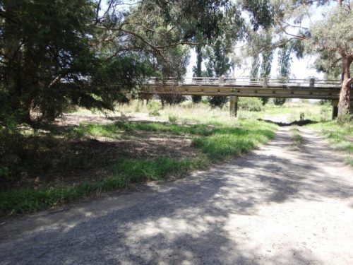
- You can catch public transport to Warburton (or to Lilydale) then begin walking the Upper Yarra Track (See: http://www.finnsheep.com/Track%20Instructions.htm) You can continue on it until you reach Rawson (resupply – some supplies also at Baw Baw Village) and the nearby Poverty Point Bridge, then canoe the Thomson River until you reach the Cowwarr Weir. NB You will have to walk around the Horseshoe Tunnel just below the Thomson River Road Bridge (See: http://www.theultralighthiker.com/upper-yarra-track-sidetrip-horseshoe-tunnelcoopers-creek/) You can carry on with the Thomson to Sale or you can walk back from Cowwarr (resupply) till you are just out of Traralgon where you cross the Latrobe River. Put in there and drift down via Rosedale (resupply) to Sale. Catch a train back to Melbourne.Thomson River Horseshoe Tunnel.
- Catch a bus to Noojee (weekdays – supplies), then canoe the Latrobe river all the way to Sale. (Supplies Noojee, [Willow Grove], Yallourn North, Rosedale) Catch a train back, or
- For a shorter trip, you could canoe from Noojee to the Yallourn Power Station – exit the bridge across the Eastern end of Halls Bay, Lake Narracan or Sir John Monash Reserve opposite the cooling towers. Walk back along the Moe-Yallourn North Rail Trail (See 4). I suspect you can put in uptream of Noojee (so that you could access the river via a shortcut from the Upper Yarra Track not long after Starlings Gap – this requires exploration). The section from the Noojee Road Bridge/Toorongo River confluence has been checked: (though you should be able to put in at Noojee township); there are a number of spots where you will have to get out. If canoeists bring along some clearing tools (See: http://www.theultralighthiker.com/canoe-clearing/) the trip/s will become easier for subsequent ‘adventurers’. There are many lovely spots where you can camp. Trout and spinyback crayfish abound – so bring some tackle! I estimate 2-3 days Noojee-Yallourn Power Station. Train Back from Moe, or
- You can catch a train to Moe, walk out along the Yallourn North Rail Trail (http://www.theultralighthiker.com/upper-yarra-track-update-section-one-moe-yallourn-rail-trail/), put in to the Latrobe near the Yallourn Power Station and canoe to Sale. There is a weir to negotiate shortly after the Yallourn North Road bridge. You can see it from the road. Train return, or
- You can catch a train to Moe, walk up the Upper Yarra Track sections (See 3) until you reach the Thomson Bridge, (supplies Yallourn North, Erica, Cowwarr) canoe the Thomson, walk back along the rail trail from Cowarrr to Traralgon. Catch a train back.

- Tom’s Bridge Latrobe River.
- Arriving at Noojee (supplies) whether by public transport or on foot via the Upper Yarra Track & etc, put in and canoe down the Latrobe River to Camp Rd near Hill End. Walk up Russell Creek Rd &/or Rowley Hill Rd (or hitch to Costin’s Rd). Canoe down some of the Tanjil River (eg to Old Tanjil Rd) then walk up to the Western Tyers via Burns Rd & eg Wombat Rd & Tanjil Bren Rd. You can put in at Christmas Creek or Growlers. Canoe down the Tyers to Caringal. Walk across to the Thomson via Erica (supplies) as in 7 or continue on to the Latrobe and Sale (Resupply Tyers, Rosedale).

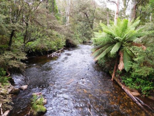
- Tanjil River downstream Rowleys Hill Road.
- Walk across from Noojee to the Western Tyers via Tanjil Bren (See: Upper Yarra Track winter route in Track Instructions above). You can continue on the Tyers till you reach the Latrobe and follow it to Sale OR
- You can get out at Tyers Junction (Caringal) and walk up the rail trail to Collins Siding and thence to Erica. You can continue to follow the rail trail http://www.theultralighthiker.com/upper-yarra-track-section-five-erica-to-walhalla/ to the Thomson Road Bridge, then canoe the Thomson as in 1

- Western Tyers River.
- Interrupt your voyage down the Thomson at Deep Creek which you can walk up (see 9 following) or canoe to the Weir, cross it North on the old wooden bridge, follow the road North till you turn left at the intersection with the Stoney Creek Rd. Walk up the Stoney Creek Rd. When you get to the T10 track, no longer marked – it is opposite a fire dam on the right hand (East) side of the road, you can either continue on to Binns intersection with the McEvoys track (also called Springs Rd) or
- You can walk down the T10 till you reach Deep Creek and walk all the way up Deep Creek till it splits in two. Just where it splits, if you walk up the left (West) fork about twenty yards you will find you can walk up the ridge to your right. You can follow this ridge (on an overgrown logging track after a while) all the way to Binns. The walk up Deep Creek is extraordinarily beautiful. It is quite a lot of bush bashing, but worth it. There are some flat camp sites here and there at the end of ridges. After Binns you can carry on up and over Mt Useful then take the South Road and Jamieson Road until you arrive in Licola (resupply) or
- Cross the Glenmaggie Creek at (eg) Porters Track to the Black Range Rd. Go up the Black Range Rd to Burgoynes Track, follow it to the Macalister. Canoe down the Macalister till you get to Sale (resupply Maffra).

- Macalister River upstream Cheynes Bridge.
- If you continued on towards Licola along South Road you can turn East and walk down to the Barkly/Macalister (Primrose Gap – off the Jamieson Rd) at the Barkly Bridge North of Glencairn then canoe down the Macalister to Licola where you can continue on till you come to Sale , or
- You can get out at Licola and walk up to the Wellington as in 13 or
- Better yet, walk up the Mountain Margaret Track (just out of Licola) until it intersect with the Tali Karng walking track…
- Instead of continuing on the Macalister, get out at Cheyne’s Bridge and hitch a ride past Licola (resupply) to the Wellington River. Walk up the Wellington past LakeTali Karng and continue till you come out on the Moroka Rd. Turn west onto the Moroka Rd. After a few km you can pick up the Moroka Walking track (also called McMillans Track) which takes you down to the Moroka River near Higgins yards. You can put in here and follow the Moroka to its confluence with the Wonnangatta, or

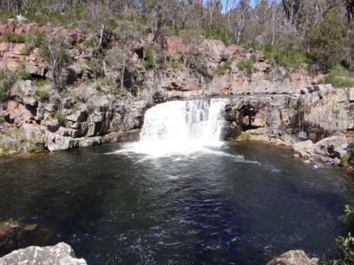
- Moroka Falls
- You could walk to the Moroka Bridge near Horseyard Flat and canoe the Moroka down to the Wonnagatta, thence to Bairnsdale. The huge waterfalls and gorge in the Moroka are very dangerous!
- Instead of starting at the Tali Karng car park on the Wellington, you could hitch all the way either to the Moroka Bridge near Horseyard Flat (12) then canoe down the Moroka or
- You could hitch up the Howitt Rd to near Guy’s Hut, then walk down the Dry Creek track to the Wonnangatta. Carry on walking down the Wonnangatta till you come to the Humffray Confluence whence you can canoe the river all the way to Bairnsdale as in 17.

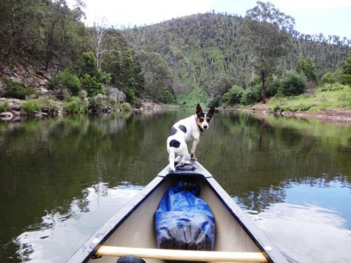
- Wonnangatta River Mt Darling Creek.
- From the Wonnangatta confluence you can continue all the way to Bairnsdale where you can catch a train back to Melbourne. Resupply Guy’s Caravan Park, (Waterford) by arrangement & Lindenow (or hitch into Dargo and back.)

- Wonnangatta River.
- Alternatively you can walk up the Wonnagatta from the Moroka to the Humffray Confluence following the true right bank (there is an old pack track – it is some years since I cleared it, but you will find your way – maybe take a machete and help out with the track clearing. There are many lovely campsites along the Wonnangatta, the first is at the Mt Darling Creek confluence). Put in at teh Humffray and canoe down to Bairnsdale.
- Mitchell/Wonnagatta River downstream of Waterford
- PS; If you walk the Upper Yarra Track (Warburton to Mt Whitelaw) then the Alp Track to near Woods Point, you can pick up McMillans Walking Track which gives you access to the head of the Macalister (downstream of Glencairn), the Moroka (near Higgins Yards), the Wonnagatta (Moroka confluence).
- PS: Massdrop has the Klymit Lightwater Pack raft (<1kg) on sale again for around $US100. With care (and a little repair it will get you lots of places or you can go the whole hog and buy an Alpacka here: http://www.alpackaraft.com/ Their lightest raft is the ‘Ghost’ Scout at 600 grams! But you might be better with the Alpacka at 2166 grams. I also have one of these. I have the Manta Ray Carbon paddle at 840 grams. It is a very tough paddle You will find the lightest paddles here: http://www.theultralighthiker.com/ultralight-paddle/
- Have fun and Happy Paddling!
- PS: Don’t forget to take some fishing tackle. Some hand line is really all you need to catch blackfish and trout (using set lines on whippy saplings if you like – I am told such ‘springers’ are now illegal in Vic!) You can use the heads etc as bait for crays. A folding landing net would be an asset (and some Alfoil!)
- I’m sure readers can help me with some of extra information, as well as suggesting some additional/alternative routes – I know you can get to Hotham and Omeo by bus, for example This gives one walking access to the Mitta Mitta (canoeable downstream from above the Glen Valley Bridge) Resupply Dartmouth, Mitta Mitta, etc. Train back from Albury – or continue on to SA. You could walk up along the Alps Track from Mt Whitelaw to reach Woods Point (supplies) which might begin a journey for you down the Goulburn (public transport back from Shepparton/Seymour) & etc. Getting onto the Snowy would also be good. I will think about that some more…and I have!
- The Snowy: You may not know there is public transport to Bombala from Melbourne/Canberra: https://www.ptv.vic.gov.au/timetables/linemain/1718 The Snowy is canoeable from Cambalong Road 6km West of Bombala. (Ask: the bus driver may let you off at the Cann River turnoff saving you a few miles walk). You will need plenty of food! It is almost two weeks from here to Orbost…Bus back from Orbost.
- Also, note: The bus stops at the Bemm River turnoff. This means you can walk ‘The Wilderness Coast’ (19 days to Eden!) using public transport! A packraft would help with getting across some of the inlets along the way!
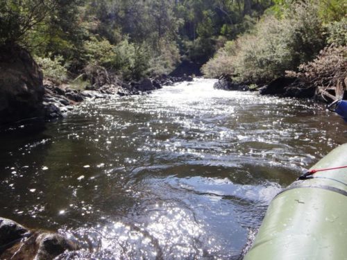
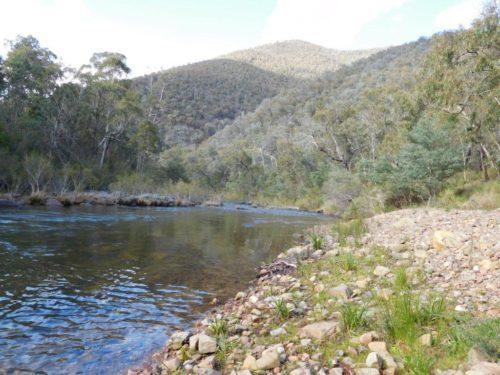
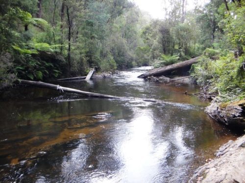
- Top Photo; Latrobe River near Noojee Road Bridge.
See Also:
http://www.theultralighthiker.com/dusky-track-canoeing-the-seaforth/
http://www.theultralighthiker.com/tanjil-river-canoe-trip/
http://www.theultralighthiker.com/canoeing-gippslands-rivers/
http://www.theultralighthiker.com/canoeing/
http://www.theultralighthiker.com/canoeing-the-thomson-river-gippsland-victoria/
http://www.theultralighthiker.com/videos/thomson-river-canoe-trip/
http://www.theultralighthiker.com/tanjil-river-canoe-trip/
http://www.theultralighthiker.com/tanjil-river-canoeing-update/
http://www.theultralighthiker.com/canoe-clearing/
http://www.theultralighthiker.com/canoeing-the-macalister/
http://www.theultralighthiker.com/tin-canoes/
http://www.theultralighthiker.com/canoeing-the-macalister-river/
http://www.theultralighthiker.com/canoeing-the-macalister-2/
http://www.theultralighthiker.com/canoeing-the-thompson-river/
http://www.theultralighthiker.com/hornet-lite-pack-raft/
http://www.theultralighthiker.com/klymit-packraft/
http://www.theultralighthiker.com/home-made-pack-raft/
http://www.theultralighthiker.com/faux-packraft-vs-alpacka-raft/
http://www.theultralighthiker.com/pack-raft-saves-the-day/
http://www.theultralighthiker.com/pack-rafts/