If you want to move around in the bush with confidence without getting lost (and without artificial aids, except for noting the general northerly direction from the sun or its shadow – eg on your thumbnail: http://www.theultralighthiker.com/finding-your-way/) You should always take note of the ‘fall’ of the country. The fall is the slope of the country; if you follows this slope, however slight, you will come to a watercourse in time, even if it is only a small dry gully. This in turn will lead down, getting larger as it is joined by other gullies and creeks until it reaches the river, and the fall of the land will continue until the sea is reached.
NB: To accurately judge distance, use this great trick: http://www.theultralighthiker.com/man-is-the-measure-of-all-things-pythagoras-some-handy-estimation-tricks/
So as you move about you always have this fall as a reference point in the back of you mind. You might say you are on the ‘southern fall of Mt Darling Creek’ or the ‘west fall of the Wonnangatta River’. Starting from a known point you will move about quite freely,confident that all the little gullies and creeks that you may cross lead back to the river system that you are using as a reference.
Whichever way you move, whether up or down, or in any direction, you are always conscious of being in a sort of bowl, and at the very bottom of the bowl is the river.
If you move on to higher ground, when you reach the highest point you will look for a change in the fall of the land. The next slope will lead to a different creek, and this may join the earlier river that you are using as a point of reference, or it may run into a totally different river system. If you can deduce this information then you can move around this basin with the same confidence that you used to traverse the first.
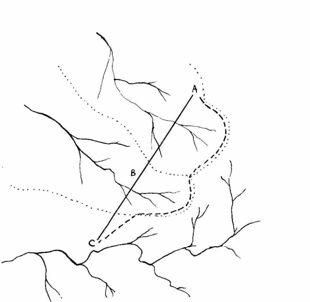
Suppose you are traveling from A to C below

While you are moving around A you should be conscious of the fact that all the fall of the land is towards creek A, and know that this will eventually join the main river.
As you move up to the highest point, you should realise that as this is the highest point, it must be the divide between area A and area B. Usually this is called simply the ‘divide’. You should then try and establish a mental picture of the new system which you have to cross. Is the fall in the same general direction? If so then it may well be a creek system that will in turn join back to the main river. If not, then what is its general direction?
Having established the general direction of the fall, the you will be able to proceed with confidence. In this case you will have noted that the general direction of the main creek is the same as the previous one, and will therefore assume that they are both tributaries of the same river.
As you proceed you will also be taking into account the fact that the small gullies feeding into the main creek do so at an angle to that creek, and you will also use this to help you keep your directions. Because you have formed a mental picture of the creek system A and have related this to the new creek system B, you can now move across this new creek system with confidence, secure in the knowledge that as long as you continue to keep the fall of the land to your right side, then you will be traveling in the correct general direction.
In time you begin to climb, and once more reach a new ‘divide’. Before moving on you establish that in this case the new creek system is running at an angle to the previous one, and in order to keep to the correct course you must travel in the same direction as the small tributaries of this creek. In this way you will arrive at the general position of your objective.
Usually you only attempt to travel in such a straight line if the country is gently undulating. If you encounters steep gullies and deep creeks you would simply follow the divide itself, following the course indicated by the heavy dotted line. (NB that sambar deer love the heads of such gullies as camping spots!) You would still locate yourself mentally by comparing the direction of the creek A with creek B, and in turn their relation to creek C, but will have the added advantage of being able to keep two creek systems in sight all the time, thus allowing greater precision in your path finding.
Notice how the early explorers used this system to move with confidence over unknown territory. Kennedy for instance made constant reference to the ‘Divide’ when he explored Cape York. He knew that if the rivers that he crossed were flowing to the East then he was not very far from the coast, but if they flowed to the West then the Divide must be on his right side. Similarly Mitchell crossed all the westward flowing rivers on his way to Victoria. It was only when the rivers began to flow away to the South or East that he knew that he had crossed the Divide. By observing the lie of the land (and his compass) he was then able to make his way back again
NB: So that your return jouney will be easy and you will not ‘get bushed’ you should fall into the habit of taking a brief spell every few minutes and turn and face your starting point while you ‘catch your breath’ observing carefully what the country looks like from that direction, and particularly how your route proceeded in comparison to the lie of the land. This way you will easily be able to make your way back. This is even the case if you do not return by the same route, but usually walk a circuit (as I normally do when hunting in order to cover the most country). If you have looked back and noted where your starting point was and how you got where you are, and paid careful attention to the shape and lie of the land, you should have no difficulty returning to your starting point even by a different route. NB: Usually following the ridges (or the divides) is the easiest route.
See Also:
http://www.theultralighthiker.com/how-to-light-a-fire-in-the-wet/
http://www.theultralighthiker.com/rope-dont-leave-home-without-it/
http://www.theultralighthiker.com/finding-your-way/
http://www.theultralighthiker.com/the-lie-of-the-land/
http://www.theultralighthiker.com/the-importance-of-a-roof/
http://www.theultralighthiker.com/carry-a-knife/
http://www.theultralighthiker.com/if-you-could-only-carry-two-things-in-the-bush-what-would-they-be/
http://www.theultralighthiker.com/ultralight-poncho-tent/
http://www.theultralighthiker.com/the-pocket-poncho-tent/
http://www.theultralighthiker.com/naismiths-rule/
http://www.theultralighthiker.com/weather-lore/
http://www.theultralighthiker.com/walking-the-line/
http://www.theultralighthiker.com/follow-your-nose/
http://www.theultralighthiker.com/how-long-till-sundown/
http://www.theultralighthiker.com/how-to-avoid-being-wet-cold-while-camping/
http://www.theultralighthiker.com/fire-on-the-snow/
http://www.theultralighthiker.com/river-crossings/
http://www.theultralighthiker.com/an-open-shelter/
http://www.theultralighthiker.com/poly-tent-by-the-ultralight-hiker-on-the-cheap/
http://www.theultralighthiker.com/how-to-avoid-being-wet-cold-while-camping/
http://www.theultralighthiker.com/new-ultralight-survival-shelter/
http://www.theultralighthiker.com/survival-still/
http://www.theultralighthiker.com/collecting-water/
http://www.theultralighthiker.com/dehydrated-water/
http://www.theultralighthiker.com/the-twelve-woodlores-ray-mears/
http://www.theultralighthiker.com/if-you-could-only-carry-two-things-in-the-bush-what-would-they-be/
http://www.theultralighthiker.com/inflatable-insulated-clothing/
http://www.theultralighthiker.com/the-importance-of-a-roof/
http://www.theultralighthiker.com/pitching-the-poncho-warning-this-may-save-your-life/
http://www.theultralighthiker.com/fun-with-sticky-tape-mylar-poncho/
http://www.theultralighthiker.com/worlds-lightest-tarp-clip/
I tried to take all of that onboard, and have done my share of short-courses in navigation but I still think I could get lost if you spun me in a circle 3 times. I praise the marvel of GPS technology daily.
Adam, Thank you for your comment, and your honesty. I really think you need to find your way without electronics or you will one day get yourself into serious difficulties due to an over-reliance on gadgetry. Please read it again (and the other relevant links) and if there is still something I haven’t explained adequately I want to know, so I can put it right. Cheers, Steve.