Adventure Pro. This is a great site for information about canoeing just so many wonderful streams in Australia. In this particular section they showcase little known and difficult sections, or ‘steep creeks’ such as the Moroka which I have copied below (hope they don’t mind). This is the section I talked about hiking/pack rafting in this post: Gully Walking
Class: IV- V (p)
Season: As the catchment is in a rain shadow the season is limited to as the snow melts in August/Sept (provided they get snow) or when there is a big rain in the area
Gradient: Approx. 20m/km (max 100m/km)
Time: 3 days paddling (maybe with high water could be done in 2 long days)
Length: 32km on the Moroka
Level: If you can just paddle the first rapid after the first waterfall then there is enough water to get down, good flow here will may give you too much water later on. (This is definitely all guess work)
Shuttle: Epic, shuttle driver required
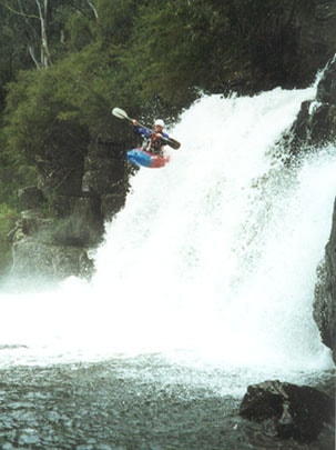
Character: Very steep alpine river that plunges through a narrow gorge with seven big waterfalls and lots of tight bouldery rapids
Suits: Definitely a creek boat river
 Rising on the back of Mt Wellington, the Moroka meanders its way along various high plains before plunging its way through the spectacular Moroka Gorge.
Long known to bushwalkers and four wheel drivers alike as a spectacular area for exploring the waterfalls and dipping in the cool water, with lots of hard work it reveals itself, when caught at the right moment, to be a spectacular and rewarding river trip.
After negotiating the road up, which can get blocked by snow, probably exactly when it is best to paddle, the first obstacle is the walk in.
Whilst 3km is not too far, doing it with fully loaded kayaks for a 3 day trip is challenging. There is an excellent walking track that leads from Horseyard Flat down into the gorge. The put in is the first waterfall you come to.
Basically this is a full-on trip, the rapids are very steep with logs and pinning rocks being a constant problem. With a lot of water, the river would at times become an almost constant cascade.
With this in mind, though, at relatively low water levels there are a surprising amount of runable rapids that will keep your interest.
 While there are many steep and interesting sections on this run, the two ‘crux’ sections would definitely be: about 1km after the start; and the kilometre of river after the last marked waterfall.
The first section soon after the start, while not being super steep is a very intricate tangle of boulders with a few logs thrown in for good measure. While there is a way through it all, extreme care should be taken by scouting.
The second ‘crux’ section comes right after you down climb the last marked waterfall, the river is very steep here, around 100m/km, and the gorge is tight. With high water some rapids would be very hard to portage or scout. In both sections there are far too many rapids to describe.
 The rapids, gorges and waterfalls continue for quite a long way after the last marked waterfall, Clear Country Ck being the point you can really relax for the paddle out.
There are two other waterfalls not marked on the map, one at GR958548 and one at GR930556.
This is one of those trips that you need to research well and plan thoroughly! It travels through some of the most remote, and spectacular country in the state with a 1000 vertical metre walk out being the easiest option of escape in some places.
Catching the right water level is also something you will have to research well, studying weather charts over the winter before to see if it will run.
Rope skills are also a must, as several of the portage’s have some quite intimidating down climbs and boat lowers — at least 20m of good rope is required.
For those who have the skills, dedication and that little bit of luck to do a trip on the Moroka, it will be a trip they will remember well for all time.
 Tim Wallace – Paddled the Moroka recently. Would describe the level as low. Was a mixture of fun rapids and not so fun rock bashing with an emphasis on the later.
However, the amazing surrounds and wilderness feel of the trip definitely made up for this.
I would suggest the Moroka gorge could take quite a bit of water before it becomes unmanageable. The structure of river bed is such that in the steepest parts of the river it kind of fans out in multiple channels and I think that even with quite a bit of water (suggest high levels on the Avon/McAlistair/Mitchell might be a good indicator) it would be the ultimate trip; continuously fun rapids to keep you on your toes, combined with the high wilderness values and amazing surrounds.
Putting In: From Melbourne follow the Princess Highway 162km East to Traralgon where you turn North and head 98km via Heyfield to Licola. Take the Snowy Plains Road up through Tamboritha Saddle to Arbuckle Junction, turn right and follow the Moroka Road all the way to the turn off to Horseyard Flat. It is about 2 hrs from Licola to Horseyard Flat with Arbuckle Junction being about halfway.
Taking Out: Head back the way you have come all the way to the Princess Highway. Continue East, 22km East of Stratford, turn off to the left toward Fernbank and Dargo. There are also signs on this turn off to the Mitchell River National Park. Follow this road North for about 10km to the ‘Fingerboards’ intersection and turn left toward Dargo. Once on this road it is about 45km of winding road till Waterford is reached, turning off this onto the Wonnangatta Road and another hour or so up to Eaglevale. You can take out here, or continue further up the river on 4WD tracks closer to the junction of the Wonnangatta and Moroka, the road stops short of the junction as it has been washed away at GR932669 and doesn’t continue as far as marked on the map.
Map: Tamboritha – Moroka 1:50000
Camping: There is excellent camping at Horseyard Flat and Eaglevale and many places in between.
See Also:
http://www.theultralighthiker.com/2017/11/22/remote-wonnangatta-day-two/
http://www.theultralighthiker.com/2017/11/15/a-wonnangatta-spring/