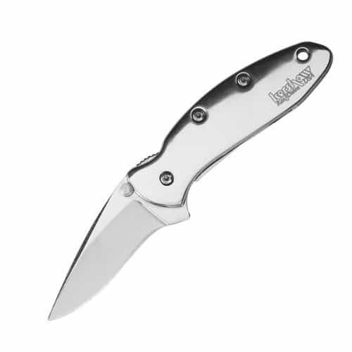
Backpacking

Moroka Gorge Falls:

  A friend sent me a digital copy of this C19th Von Guerard painting (above). I have lurked in the Mount Darling-Snowy Bluff Wilderness quite a lot…I thought we had been to the Moroka Falls (twice – eg http://www.theultralighthiker.com/camping-by-the-moroka-river/) but we had only been to the UPPER Falls – as the clip from Vicmap Moroka

Moroka Gorge Falls: Read More »

Upper Yarra Track: Winter Route: Western Tyers: Morgans Mill & Skinners Camp:

From Caringal you can journey to Western Tyers via Morgans Mill Rd (open forest) or Buckle Spur, cool wet forest tree ferns and mountain ash. Probably 2-3 hours either way. There used to be a walking track along the river which followed the old railway line all the way to Growlers, but it has grown

Upper Yarra Track: Winter Route: Western Tyers: Morgans Mill & Skinners Camp: Read More »

Upper Yarra Track: Winter Route: Caringal Scout Camp: Tyers Junction

You might reach here by walking down the rail trail from Collins Siding (10 km – 2-3 hours), where the cottages are on the main Erica-Moe Rd at the Caringal turnoff. The trail runs along behind the cottage on the West side starting to the North of them. Or, you might come down the East

Upper Yarra Track: Winter Route: Caringal Scout Camp: Tyers Junction Read More »

A Beautiful World:

We did a little afternoon excursion today to check on the existence of some old walking tracks around Erica. The first pic is of Steve Jones with Spot where the walking track disappears at Tyers Junction near the Caringal Scout Camp. It seems to be one of the ‘roads less traveled’ judging by the overgrowth

A Beautiful World: Read More »

Upper Yarra Track Summary: Cumulative Distances/Times:

NB: This is a summary. These are ‘retiree’ walking speeds. The distances are approximate. You may do the trip much faster, but what’s the hurry? The whole trip would take us (combined age 130) about ten days. Moe-Walhalla will take 2-4 days. If you are young and fit you should be able to ride that

Upper Yarra Track Summary: Cumulative Distances/Times: Read More »

Upper Yarra Track: Section Four: Moondarra to Erica:

When you come to the end of the Wirilda Walking Track, our walk continues on East along the W18 through beautiful serene forest. The first suitable campsite, a really beautiful spot with water is when the trail crosses Jacob’s Creek on the Old Traralgon ‘Road’. 20 km – 5.5 hours Lake Moondarra   It is

Upper Yarra Track: Section Four: Moondarra to Erica: Read More »

Upper Yarra Track: Section Two: Yallourn North to Wirilda Park

(@15 km – 3.5-4 hours) This section is easy going along quiet country lanes with lovely vistas and ample shady spots if you need a roadside rest to enjoy the view. You look out Southwards over the verdant Latrobe Valley towards the beautiful Strzelecki Ranges, a tongue of forest which extends all the way down

Upper Yarra Track: Section Two: Yallourn North to Wirilda Park Read More »

Cheapest Mobile Phone Service

Why have a mobile phone plan when you can have a telephone number (with lots of calls for $5/month via Voip and can buy data for as little as $50/year for 5Gb? Add: Acrobits Softphone App (Play Store = $6.99); Plus: eg https://www.pennytel.com.au/personal-voip/plans/talk-till-you-drop $5/month includes DID phone number; Plus: https://www.telstra.com.au/tablets/prepaid-for-tablets $50/year for 5Gb. $140 for

Cheapest Mobile Phone Service Read More »