Avenza has morphed into a really great mapping tool. I used to use the previous free version (PDF Maps) in conjunction with bought versions of Vicmap topographical maps but abandoned it in favour of Paper Maps a few years ago. Today I took a fresh look at it. Now it has a vast swathe of free maps of most places but for me the best bit is lots of maps of Victoria.
PS Dec 2025: Once again, after the last update (Nov 2025) this App is refusing to open my owned Vicmaps which I have stored on my phone. The solution is to Uninstall the App and download an older version eg 5.4 here (which worked when I did this post). I have done this with other Apps (eg Paper Maps – see post) though it is a little tricky if you have never done so before. After you have done this you will have to go to Google’s Play Store open the App then turn off Automatic Updates (by clicking on the three dots at the top of he screen). Then the App will keep on working for you. You can do the same for other Apps which have updated and stopped working.
I was quickly able to download excellent georeferenced topographical maps of my favourite places in the Victorian mountains –including where I live (Yinnar area) so I know that the maps are indeed georeferenced as my location showed the instant I opened the map. There is our house already Placemarked ‘Home’ as you can see.
I have never seen an App which finds your location as quickly as this one. I used it this afternoon on our walk. As soon as you pressed the location arrow on the App it moved the map to one’s present location – even in thick bush. Also, as you walk it tracks you constantly.
This topographical map looks just as good as the bought Vicmaps version I also own but this one downloaded in seconds and was free. Why pay more?
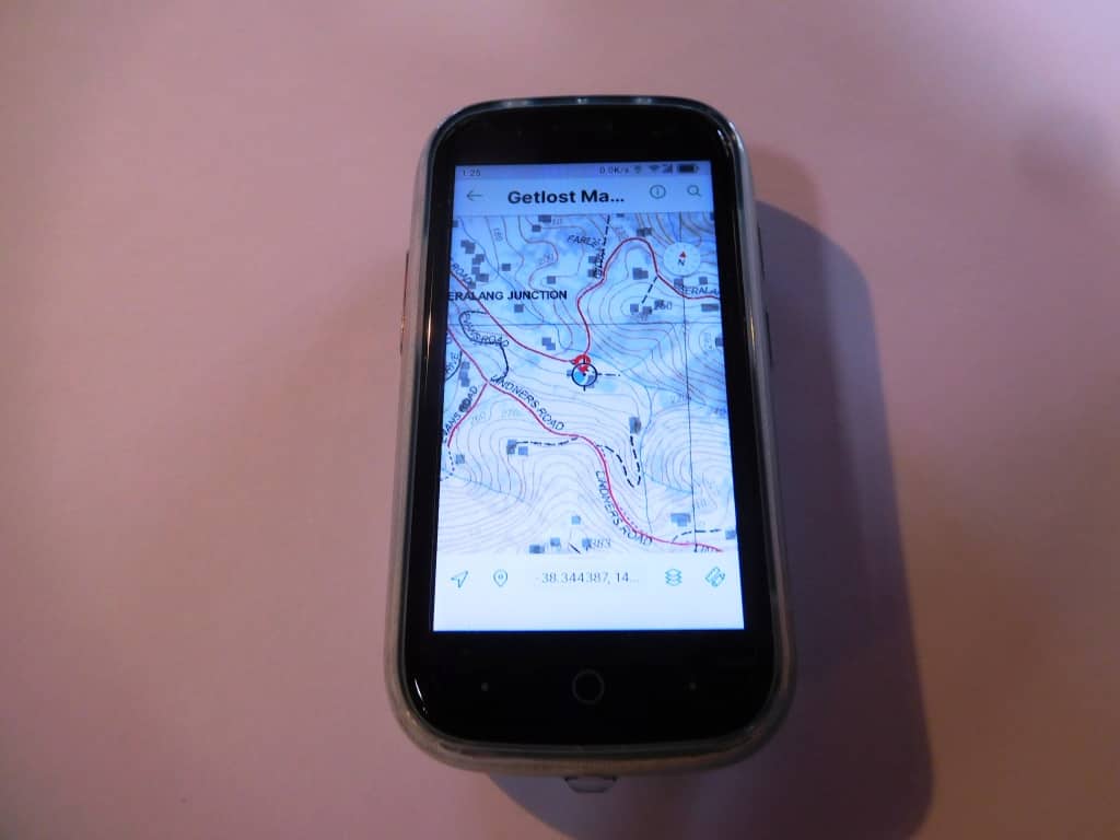
This is a screenshot of my new fob pocket phone the Jelly Star – what a beauty it is. I have already been posting (48 megapixel) photographs taken with it – the raft ones below for example.
Here are just some of the maps on offer for one of my favourite areas (Mt Darling Snow Bluff Wilderness Area). If you could just scroll down you would see lots more. When you click on the green dot it shows the name of the map and the area covered. Most of the maps are free.
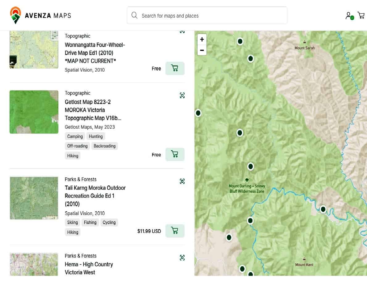
I downloaded the Moroka topographic map (again pretty much identical to the similar one I also own) as well as a heap of Fedwalks maps (of the area) – further down the page – which also look excellent. Some overnight trips I am already keen to do.
You should definitely be able to use this App for hunting, hiking and offline navigation in general. No-one needs to get lost any more.
A useful feature is that you can create a route with it (as well as put placemarks on it. I have (for example) created a route of old closed roads (in this case going in to Mt Darling where I intend to go again shortly – because no-one else does!) so that I can use it to (re) locate them when I get off-line.
I have a downloaded copy of all the old Vicmaps which still have these closed roads (and possibly some other missing features such as old huts) on them. Unfortunately the old Vicmaps are not Georeferenced but by copying the bits I needed across to the GetLost map I have overcome that problem. I have tried Georefencing them but didn’t get it quite right.
I find it useful to mark a route down a ridge I intend to follow too as particularly in the high (flat) country it is quite difficult to follow a ridge downhill without sometimes accidentally diverting off to another one when they split. Now just a quick look at my phone tells me when I am still on the right ridge.
Sometimes an old road has become too overgrown and it is easier to take to a ridge and then re-join it later. I hope to complete a loop completely around Mt Darling Creek sometime in the future and maybe drop down into the Congromerate Creek, and so on to the Wonnangatta.
Sometimes you can spot a suspiciously green area (ore even water) on Google Satellite View (maybe high up a creek or even close to a ridge) which may indicate a soak which could be developed as a water source. I think it is worth marking them.
Another couple of Offline Map Apps you definitely should have on the phone so as to prevent just such geographical embarrassments are Maps.Me which also allows you to download free maps of various parts of the world. I now have Victoria on mine. We also used this for navigating in Kathmandu & Nepal where we were Surviving the Everest Base Camp Trek recently.
I also like the Sygic App (which also allows you to download a free map of your locale (eg Victoria, Australia) as it has a satellite (picture) layer which makes it much easier to see just where you are.
Another useful App is the Australia Topo Maps App. It has a fairly large scale free topo map of the entire country good enough to tell you where you are and to prevent your becoming lost. I have these last three on my phone all the time so that no matter where I go in Victoria/Australia I will know just where I am at the press of a ‘Location’ button.
NB: Get Lost Maps has the entire Victorian 1:25,000 Topo map set for free download for use eg on Avenza or some other Apps – as well as most other Australian states.
Correction 02-12-2025: Avenza has stopped working again after an update. It will no longer open my legally downloaded Vicmaps etc. I have reverted to the Paper Maps App which can still be downloaded (free of Google updates) here. I have done so (ignoring Norton’s nanny warnings) and it now works fine.